Loading subject page…

- Civil Engineering
- Traverse and Topographic Surveying
- Area Computation by the Alternative Coordinate Method
Micro-course: Traverse and Topographic Surveying
2,228 views
Learn key concepts and earn your certificate.


Area Computation by the Alternative Coordinate Method

00:00
01:24
Video Summary: Area Computation by the Alternative Explained
Ever wondered how surveyors calculate the exact area of irregularly shaped properties like Texas ranch boundaries or California vineyard plots? Computing areas within irregular boundaries becomes surprisingly straightforward with the alternative coordinate method, also known as the shoelace formula. This technique transforms complex boundary calculations into simple arithmetic using x and y coordinates arranged in a specific pattern. Whether measuring a triangular lot in Manhattan or a pentagon-shaped park in Denver, this method provides precise results for any polygon. Watch the full video on JoVE Coach to master this concept with expert-led visuals and step-by-step explanations.
- Understand the fundamental principles of Area Computation By The Alternative Method and how it applies to irregular polygonal shapes
- Identify the correct sequence for arranging coordinate pairs and setting up the calculation matrix
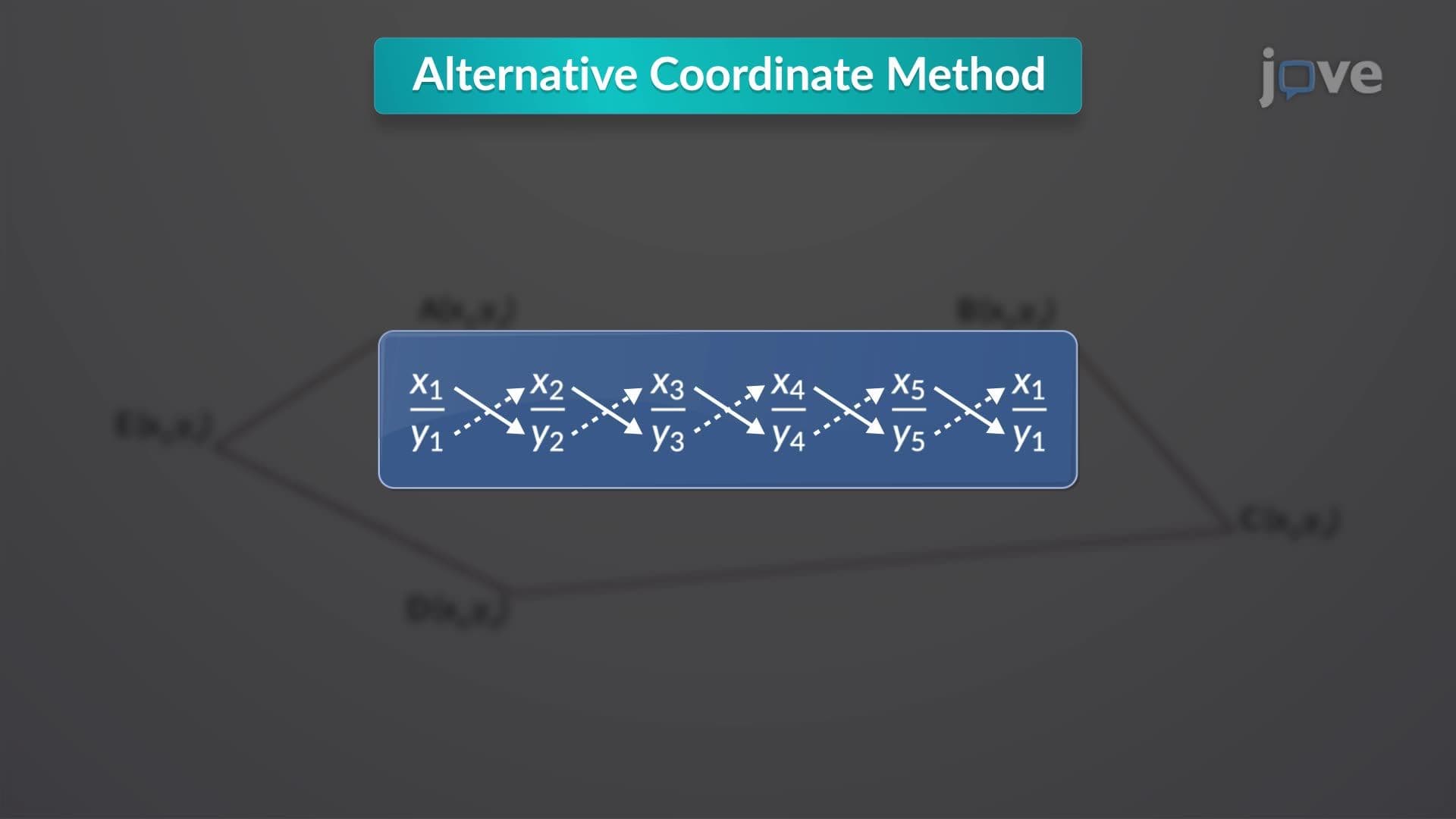
- Analyze the geometric significance of solid and dashed diagonal lines in the coordinate method
- Apply the shoelace formula to calculate areas of complex boundaries in surveying and engineering contexts
- Evaluate the accuracy advantages of this method compared to traditional geometric decomposition techniques
- Recognize when to use absolute values and division by two in the final area calculation
- Compare manual calculation methods with computer-based implementations for large-scale surveying projects
- Explore real-world applications in property surveying, urban planning, and civil engineering projects
Understanding Area Computation By The Alternative Method
The alternative coordinate method, commonly called the shoelace formula, represents one of the most elegant solutions for calculating areas within irregular boundaries. This mathematical technique transforms the complex problem of measuring polygonal areas into a systematic coordinate-based calculation that works regardless of the shape's complexity.
Mathematical Foundation and Setup Process
When working with areas within irregular boundaries definition, the process begins by establishing a coordinate system where each vertex of the boundary is represented as an (x, y) coordinate pair. These coordinates must be arranged sequentially around the perimeter-either clockwise or counterclockwise-creating a closed polygon. The method's name "shoelace" comes from the distinctive diagonal pattern created when connecting coordinates, resembling the crisscross pattern of shoe laces.
For what is areas within irregular boundaries in detail, consider a practical example: calculating the area of an irregularly shaped construction site in Phoenix, Arizona. If the site has vertices at coordinates (0,0), (4,0), (4,3), (2,5), and (0,2), these points would be arranged in sequence with the first coordinate repeated at the end to close the polygon.
Calculation Process and Practical Implementation
The areas within irregular boundaries overview reveals a two-step multiplication process. First, multiply each x-coordinate by the subsequent y-coordinate (solid diagonal lines), then multiply each y-coordinate by the subsequent x-coordinate (dashed diagonal lines). The area equals the absolute value of the difference between these sums, divided by two.
This method proves invaluable for students preparing for AP Calculus exams, where irregular area calculations frequently appear. College-level surveying courses at institutions like Texas A&M University and Virginia Tech extensively use this technique for real-world applications. The areas within irregular boundaries concept extends beyond academic settings into professional surveying, where precision is critical for legal property boundaries and construction planning.
Advanced Applications and Modern Usage
Understanding areas within irregular boundaries basics becomes essential for students pursuing engineering or surveying careers. Modern GPS surveying equipment often employs this algorithm internally, making it relevant for both manual calculations and computer-assisted surveying. The method's reliability makes it a standard tool in geographic information systems (GIS) used by urban planners and environmental scientists across the United States.
Frequently Asked Questions
Area Computation By The Alternative Method is a coordinate-based technique for calculating the area of any polygon using x and y coordinates arranged in sequence. It works by creating diagonal multiplication patterns between coordinates, then finding the difference between two sums and dividing by two for the final area.
Yes, coordinate-based area calculations frequently appear on AP Calculus AB and BC exams, particularly in applications of integration problems. The SAT Math Level 2 subject test also includes similar coordinate geometry problems. College placement exams often test this concept in precalculus and calculus readiness sections.
Engineering programs at universities like MIT, Stanford, and Georgia Tech incorporate this method in surveying, civil engineering, and computer graphics courses. Students use it for calculating areas in AutoCAD projects, determining material quantities for construction, and programming GIS applications for urban planning projects.
Real estate appraisers use this method to calculate property values for irregularly shaped lots in cities like San Francisco and New York. Environmental scientists apply it to measure watershed areas and wildlife habitat boundaries. Construction companies use it to estimate material costs for non-rectangular building sites.
Not at all-this method requires only basic arithmetic and coordinate geometry concepts typically covered in Algebra II or Geometry. Students who understand plotting points on a coordinate plane can master this technique with practice. The systematic approach makes it more reliable than trying to break complex shapes into triangles and rectangles.
Practice with various polygon shapes, starting with simple triangles and quadrilaterals before advancing to complex polygons. Focus on maintaining coordinate sequence accuracy and double-checking arithmetic. Create a step-by-step checklist to avoid common errors like forgetting to repeat the first coordinate or omitting the absolute value.
The coordinate method is more efficient and less error-prone than geometric decomposition, especially for complex polygons. While triangle decomposition works for simple shapes, the alternative method handles any polygon with the same systematic approach. It's also more suitable for computer programming and large-scale surveying applications.
This foundation leads to vector calculus applications, including Green's theorem and line integrals in multivariable calculus courses. Advanced surveying courses explore three-dimensional applications and GPS coordinate systems. Computer science programs extend this to computational geometry and geographic information systems programming.
Related Micro-courses
10 Concepts

6 Concepts
9 Concepts